
Groundwise Searches Ltd
- 01702 615566
- Contact Us
- Login
- Register
Groundwise Searches Ltd
Completed Utility search report and compiled into Desktop CAD map.
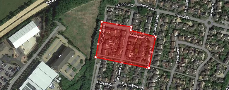
Towcester, Buckinghamshire, NN12 7AW
Confidential
Construction/Property Development
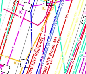
The idea of a Desktop Mapping drawing is to make the interpretation of the maps and plans of any given site, easier for our clients. Searching through pages and pages of plans takes up time that could be used much more efficiently. The Desktop Mapping drawing incorporates all the plans that would be affected by the site development and places them on one page.
A recent Desktop Mapping drawing project that we’ve completed was for a site in Towcester, Buckinghamshire. As with all utility reports that we work on, the site details were double checked and requests sent to all the utility companies that may have assets in the area. Plans and responses that were returned to us were checked against the original site plan sent to us by the client, and scanned to PDF. The Towcester job was a Standard Turnaround and so scanned versions of all the responses received after the 15 working day deadline were emailed to the client on that day.
The asset information contained within each utility plan was then transferred to CAD format .DWG on an OS background as part of our Desktop Mapping. The data and digital files were then provided to the client.
Hilltop SEND School Project location: Rotherham, South Yorkshire Client: The Great Yorkshire Build Sector/Industry: Private, Public & Third Sectors Project Information: A client...
View case studySolar Park Project location: North Scotland Sector/Industry: Renewable Energy Project Information: Our client instructed us to undertake a full Utility Search, for a site covering...
View case studyElectric Vehicle Charging Station Project location: Banbury, Oxfordshire Sector/Industry: Electric Vehicle Charging Network Project Information: Our client was at the planning stage...
View case study